Welcome to the interactive Midgard Map, a suite of digital tools for the Midgard World setting by Kobold Press.

Basic Controls

Click and drag the map to move it around. The mouse wheel or zoom buttons to the right will zoom the map in and out to various zoom factors.

On the right hand side you will find zoom, pathfinder mode, and layer controls to turn on and off various markers and map options.

The hex map is scaled at 50 miles per edge of each hex and 100 miles across at the longest points.

Sidebar

The other sections of this sidebar contain detailed information on using various tools, a help section, a Filter and Search tool, and attribution information.

Please be aware that this map may not be fully usable on mobile devices, smaller screens, or through screen reader software.

The interactive midgard map is © 2023 Open Design LLC. Midgard is a trademark of Open Design, LLC.

Additional Maps

Midgard is a large world, and there are many areas requiring more detail than the world map can provide. Click on the submaps below to go to the various city and region maps currently available.

  • Full Midgard Map
  • Bemmea Map
  • Bratislor Map
  • Bundhausen Map
  • Capleon Map
  • Cindass Map
  • Harkesh Map
  • Jozht Map
  • Konigsheim Map
  • Maillon Map
  • Nuria Map
  • Per Bastet Map
  • Reywald Map
  • Triolo Map
  • Zobeck Map

Filter and Search

You can scroll up and down the location list, or filter by name or type by entering the desired search term in the filter. Clicking on a location will center and zoom the map there.

  • Barge Souk | Miscellaneous
  • Forest of the Obelisks | District
  • Inner Wall | Miscellaneous
  • Palm Palace Of The God-King | Castles and Towers
  • River Nuria | Rivers
  • Second Wall | Miscellaneous
  • Step Pyramids of Faizal | Key Sites
  • Tombs of the God-Kings | Religious

Pathfinder Tool

To ease your journeys in the realms of Midgard, we've provided a Pathfinding tool that can help determine distances.

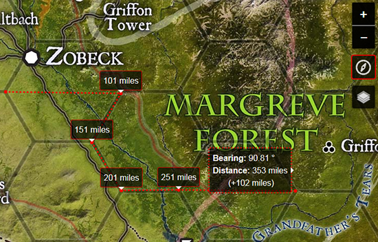
To use the pathfinder tool:

  • Click on the Compass Icon in the right hand tools section.
  • You are now in "Pathfinder" mode. When you click a location, it will mark it as your start point.
  • Move your mouse to draw a line with a tooltip that shows bearing and distance.
  • Click again to set a point in the journey.
  • When you are done, double click to close the path, or press the ESC key.
  • Press ESC again or click on the compass icon to turn off the Pathfinder tool.

Useful Links

  • 5E D&D Movement
  • 5E D&D Mounts and Vehicles
  • Pathfinder Movement
  • Pathfinder Mounts and Vehicles

Credits

The interactive midgard map is © 2023 Open Design LLC. Midgard is a trademark of Open Design, LLC.

The Cartography in the Midgard World map is by Anna Meyer. Click here to Support her work on https://www.patreon.com/annabmeyer

Coding for the interactive midgard map was created and is maintained by John Arcadian. Find him on twitter @johnarcadian or writing at gnomestew.com

Thanks to Chris Sniezak of the Misdirected Mark network for coordinates and content help.

Thanks to Chase Colman for fixing javascript bugs and reworking the math on the pathfinder tool.

Thanks to Matt Neagley for building a formula to help correct coordinate errors.


Changelog

V 2 - 07312019
  • Midgard Map Updated to Version 2
  • Content for the Southlands Added
  • Map coordinates redone to accomodate differently sized map
V 1.6 - 08282018
  • Content for 3 more submaps (Cindass, Triolo, Nuria) added.
V 1.5 - 07262018
  • Submap coding integrated.
  • Sidebar content redone to accomodate submaps.
  • Content for 3 submaps (Zobeck, Konigsheim, Per-Bastet) finished, proofed, and released.
V 1.3 - 05072018
  • Pathfinder tool incorporated.
  • Sidebar content redone.
V 1 - 04302018
  • Grid and political maps incorporated.
  • Moved all markers to marker layers.
  • Setup layer groups.
  • Redid sidebar coding for better mobile responsiveness.
  • Better help documentation for features.
V .8 - 04012018
  • Initial Public Release Version.
  • Initial Map Coding with leaflet.js library.
  • Basic Zoom Controls.
  • Markers generated by links.

Help Section

Welcome to the interactive Midgard Map, a suite of digital tools for the Midgard World setting by Kobold Press.

Map Controls

Click and drag the map to move it around. The mouse wheel or zoom buttons to the right will zoom the map in and out to various zoom factors.

Search and Filter

The search and filter feature in the infobar on the left will allow you to search map entities by their name or category.

Patfinder Tool

The Pathfinder tool (compass icon) lets you measure the distance along paths. Find detailed info in the Pathfinder tool sidebar section.

Map Versions and Markers

You can turn various map versions on and off with the layers control to the right, including the hex grid map and the political boundaries map.

Hex Grid Version

The hex map is scaled as 24 miles across each hex.

The interactive midgard map is © 2023 Open Design LLC. Midgard is a trademark of Open Design, LLC.